Accessibility and Mobility Plan

We are developing a plan to address barriers to safe and accessible non-motorized travel by those with physical disabilities on city streets. Thank you to all who participated in our survey tools! We are currently analyzing your feedback.
The City of Ridgefield is developing an Americans with Disabilities Act (ADA) Transition and Mobility/Access Plan to guide when and where mobility improvements need to be made. Using the Plan, we will develop a program of projects to remove gaps and barriers to accessible non-motorized transportation within City limits.
The Plan development consists of surveying public streets for gaps and barriers to mobility for those with physical disabilities, and evaluating access to public buildings, facilities and parks. The final plan will address improvements on a holistic basis by prioritizing key trip origins and destinations within Ridgefield.
Community Engagement
The development of a comprehensive ADA Transition Plan requires feedback from community members just like you. Thank you to all who participated in our survey! We are currently analyzing your feedback.
The public participation process includes an opportunity to identify and submit locations where there are gaps and barriers to accessible travel along the city’s main corridors, as well as help identify the key trip origins and destinations where accessible non-motorized travel is critical.
Study Area
The ADA Transition and Mobility/Access Plan’s study area will include collector and arterial roadway corridors within the Ridgefield city limits, including Pioneer Street, Hillhurst Road, Royle Road, Carty Road, Reiman Road, Main Avenue, Heron Drive, 65th Avenue and 85th Avenue. Additional neighborhood collectors may also be included.
Potential public facilities include: City Hall (230 Pioneer Street), Ridgefield Police Department (101 Mill Street Ste 110), Ridgefield Community Library (210 N Main Avenue), Ridgefield Junction Park-and-Ride, Future Community and Recreation Center, Community Parks (Davis, Abrams, Overlook, Community & Skate, Eagle's View, Refuge/Off Leash Dog Park, Ridgefield Outdoor Recreation Complex), and Ridgefield Administrative and Civic Center (510 Pioneer Street).
The Americans with Disabilities Act
The Americans with Disabilities Act (ADA) requires an ADA Transition Plan from public entities having responsibility for, or authority over facilities, streets, roads, sidewalks and/or other areas meant for public use (collectively referred to as “facilities”). This Plan must describe how facilities will be transitioned to meet federal accessibility standards.
Next Steps
Thank you to all who participated in our survey! We are currently analyzing your feedback.
The plan is currently in development and will be presented to City Council for approval in 2026.
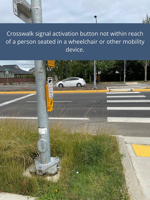
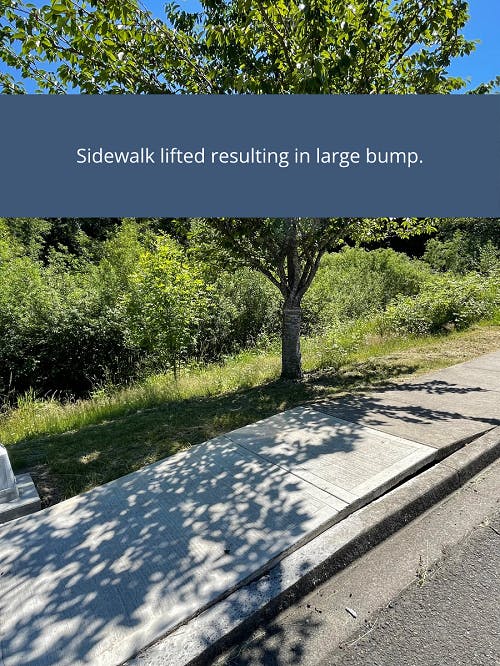
Examples of Barriers


Custom
